The Ancient Silk Road : (1) Qinghai province route
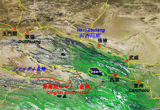
Hexi Zoulang which is known as the main route of the Silk Road is a east-wast trading path which takes a course starting from Xian of an ancient capital, and reaching to Dunhuang via oases scattering in a long and narrow desert between Lanzhou of Gansu province and the northern part of the Qilian mountain range. There is "Qinghai root" which is one of the an cient Silk Road in the south of Qilian mountains ranging almost parallel to Hexi Zoulang.
There are some branchs in Qinghai route. In addition to the existing route considering conventionally which takes a westerly course from Xining (capital of Qinghai) via Delingha, it was proved by the recent studies that there is a new route called " Qinghai south route (tentative name)" which takes a course from Dulan prefecture to Miran via Golmud in the south edge of the Quaidum basin.
This is a wide range observation satellite image (NOAA/AVHRR) overlaid Hexi Zoulang,Qinghai, and the surrounding routes of the Silk Road.
From this image, it is obvious at a glance that the Silk Road network of this region was grown by connecting oases scattering in the desert.
The ancient Silk Road : Qinghai route
(Satellite image: NOAA AVHRR & TRIC/SAA)