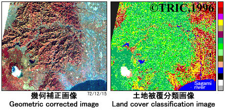
Cover Classification Using Satallite Data - cover classification of the Sagami River basin
Land cover classification of the Sagami River basin was executed by remote sensing.
Classification results of the LANDSAT image showed a high geometric accuracy and a high shadow-free classification accuracy, which was achieved with the aid of precise geometric correction, intensive test area selection and man-machine interactive tree structure classification.
Result are printed in a conventional color-coded map format in the scale of 1:100,000. An operational remote sensing data collection system with LANDSAT data was established.